Showing posts with label Gary Griggs. Show all posts

Sunday, February 2, 2014

4: Hawaiian Hotspots...a guest post from Gary Griggs

Early morning moon setting over Moana Kea (with the UCSC Keck Observatory visible at the right) in Hilo, Hawaii
Seeing the full moon set over Moana Kea as we sailed into Hilo, Hawaii, was not only a welcome sight after 7 days at sea, but was also a reminder that these islands are all volcanic, created over five or six million years as the massive Pacific Plate has moved northwest at a few inches a year over a hot spot or thermal plume rising from deep within the Earth. Six million years ago Kauai sat over the hot spot and was actively erupting, building that island up nearly 30,000 feet from the seafloor. Each island gradually formed and then died in a progression to the southeast as it moved away from the hot spot or plume. Kauai, Oahu, Molokai, and Maui each had their day, and now Hawaii sits over the plume, with Kilauea the most active volcano on Earth directly connected to a source of magma deep in the mantle.


While many of the people on the ship expected a classic steep-sided cone like Fujiyama, Mt. Saint Helens, or Shasta, the Hawaiian volcanoes are all much more subdued, being shield volcanoes, or shaped like a Roman shield resting on the ground. The difference in their shapes lies in the nature of their eruptions, which results from different lava compositions. The Hawaiian Islands consist entirely of basalt, lava low in silica. As a result the eruptions produce very fluid lavas, which flow considerable distances at only moderate speeds and are generally not a hazard to people- unless the people are moving very slowly or in the wrong place at the wrong time

The Cascade volcanoes, on the other hand, as well as Mt. Fuji, which loomed on the horizon on Yokohama as we sailed in early on the 29th of January, have a classic steep-sided, symmetrical shape. The Chain of Fire, or the volcanoes that surround the entire Pacific Ocean, contain a higher silica content, and produce sticky, explosive eruptions, which build up steep, cone shaped peaks. Our best view of Mt. Fuji came on our entry to Japan and as the weather changed, we sadly never saw it again. But Deepika did get some nice pictures (stay tuned...)

Kilauea steaming (photo by G. Griggs)
Hiking across Kilauea Iki crater (photo by G. Griggs)
I did lead a class field trip to Kilauea on a hike down into and across Kilauea Iki, which was a red-hot, molten lava lake in the not too distant past, and which is still releasing sulfur oxide fumes and hot steam. As the lava lake gradually cooled and hardened the surface subsided and left a surface looking an asphalt highway broken and cracked by an earthquake.

Site of 1959 Kilauea Iki 2000ft high eruption (photo by G. Griggs)
Kilauea Iki following the lava lake cooling and collapse (photo by G. Griggs)
Broken and collapsed lava from former molten lava lake (photo by G. Griggs)

Walking across the now hardened lava brought thoughts of walking over hot coals and led us to wonder when the next eruption was likely to occur.  Kilauea is monitored virtually continuously by the U.S. Geological Survey’s Hawaiian Volcano Observatory, through a combination of the earthquake detection beneath the volcano, GPS measurements of the slopes around the volcano to see if there is any swelling, as well as daily sampling of the gases being discharged for any changes. Fortunately, the eruptions of Kilauea are somewhat more predictable and less devastating than the volcanoes surrounding the Pacific Basin.


Lava Tree - molten lava rushed around a living tree trunk, and immediately cooled, creating a mold of the tree within
(photo by G. Griggs)

Monday, November 7, 2011

Postcards from Lhasa - Part 3 - Guest Post from historian Sandy Lydon

Welcome to the last post in the three part series by guest writer, Sandy Lydon, professor emeritus of Asian and Asian American History. He is writing direct from Lhasa, Tibet where he, along with Gary Griggs (Professor of Earth Sciences and Director of UCSC's Institute of Marine Sciences), and Cherie Barkey (Professor of Modern Chinese History) are leading an intrepid group of travelers, most of them from Santa Cruz, California, on an amazing 2 1/2 week adventure through China, Tibet, Hong Kong and Macao. You can find details about the trip itinerary on Sandy's website. Included in this post are my own photographs taken on two previous trips to Tibet - in July of 2001 and October of 2009.
Our Trusty Tibetan Drivers
Tibetan Plateau - 2001
The Road to Yamdrok Lake
We spent several months researching a get-out-of-Lhasa day and after getting advice from all quarters (but most importantly, our travel connections, Asian Pacific Adventures one of the most experienced travel wholesalers on this side of the world), we decided to do a temple-less day (a day without temples in Tibet is, well, let's just say unusual) and make a day-trip to Yamdrok Lake. The road westward along the Yarlung Valley is a dream freeway, as the highway glissades along the south bank of the river, and when the mountains press up against the river suggesting that the highway cross to the other side, the Chinese highway engineers punched tunnels – big, long new tunnels – to avoid re-crossing the river. The river is splayed out and has evidence of some high water, and building a bridge across it is no easy matter. Better to punch the tunnels.

Yarlung River
Yarlung River Valley, Tibet - 2009
The Yarlung Tsangpo, the river we are following, is the headwaters of the Brahmaputra River, that monster holy historically important river that tumbles out the Himalayas down into India. It is an amazing to realize that almost all of the Big Ones – Asia's big rivers, begin up here – the Hwang Ho (Yellow), the Yangtze, the Irrawaddy, and here the Brahmaputra. Tibet's snows are Asia's reservoir, and, as Gary Griggs has pointed out in our pre-trip session and commentaries during the trip, global warming is beginning to diminish these snows, and posing dire consequences for billions of Asia's population. The snowpack melting up here means danger for folks living in low-lying places like Bangladesh.
Mighty Bramaputra River
Tibet - 2001
Tony's Chinese History Lesson
As we rolled along beside the river, Tony began a remarkable re-counting of China's history, and for the next 45 minutes or so he wove historical and personal accounts together, compressing over 2,000 years of history (we won't worry about before the Qin Dynasty, he said…).  It might sound strange to be doing general Chinese history with Tibet rushing past the bus windows, but it was perfectly appropriate because the bus windows were fogged up and no amount of the driver jiggling the controls could clear them.  We were in a long classroom and Professor Tony, with the assistance of a hand-out, was vow-determined to reach the present-day.  Both Cherie and I have taught that sequence and were enthralled – and so was the rest of the group.
Yamdrok Lake
They were more than right about the view of the lake. As the bus topped the ridge and pulled onto a flat graveled parking area (joining a few other 4-wheel drives and one other bus of Chinese tourists), the lake spread out before us to the south, and beyond it the snow-capped Himalayan massif, and Mt. Nojin Kangtsang which is a wicked-looking wedge of snow and ice towering over 23,000 feet. Yamdrok Lake is one of the three holiest Tibetan lakes, and it is believed that if it every dries up, that Tibet will cease to exist. The Dalai Lama has visited it as has every major Tibetan historical figure. It is long and narrow beginning way off on our left and disappearing on our right. The hills framing it are bare brown rock, and the Tibetans say that the lake is shaped like a scorpion, the coiling tale out of our vision to the right. The lake is a stunning blue, and the air atop the pass is still, clear and bracing. I've never spent much time walking around above 16,000 feet, (we crossed the 16,000 foot Tangulla pass on the train), and the feeling is one of giddiness and restraint. You KNOW that you can't do much, so you don't.

There are a group of locals selling stuff in the parking lot – you can get on a yak and have your picture taken (Jane Kling, Marty Williams and Janet Jones did that), or you can pose with some formidable looking black Tibetan mastiff dogs who wear red ruffled collars that make them look like characters in a Punch and Judy show, or you can just try and discourage the young men and women selling jewelry. "Hallooooo" – "you want buy cheap?" Most of us began our visit determined not to buy something, but it might have been the altitude, or the absolutely splendor of the view, or whatever, because we bought enough jewelry to open a store.

I had been fearful of this trip as we were flying blind, trusting the recommendations of our travel professionals, and hoping that the group would be able to weather the 2.5 hour one-way trip up the switchbacks to get there. The group declared the visit to be not only worthwhile, but also one of the high points – literally and figuratively – of our Tibet stay. And as we inched slowly back down the mountain to the river, we could see why the Yarlung Valley below is called the cradle of Tibetan civilization – there just aren't that many places hospitable enough for human habitation. This is tough country.

Alan Richards noted that if you stayed on the road that dropped down and skirted the lake, you could eventually reach Nepal. We'll save that one for another trip.
Yamdrok Lake - looking south to Mt. Nojin Kangtsang and Nepal
Near Gyantse, Tibet - 2011
Photo by Gary Griggs
Prayer Flags adorning the Gamta Pass
Yamdrok Lake, Tibet - 2011
Photo by Gary Griggs
Tibet Conclusions
As we packed up and prepared for our descent to Kunming, a mere 6,000 feet, and heavier air, I was trying to find an answer, some wisdom, some Solomon-like solution to the Tibet-China conundrum. But I haven't one. Group members continued to come back from Lhasa excursions with stories about seeing the Chinese soldiers encountering the Tibetans, and none of them were nice. Even those in the group who befriended Tibetans out on Barkhor square, usually broke off the friendship after ten or fifteen minutes for fear of endangering the Tibetan. By all accounts the Barkhor is filled not only with uniformed soldiers (who seem to enjoy shouldering you out of their way), but also plain-clothed men and women with ear pieces, watching and listening for any sign of disruption or protest. I used to think that the soldiers on Tiananmen Square were pretty scary, but they are nothing compared to this occupying army in Lhasa. And, I noticed that not only were there fire extinguishers at every soldier station, most of which are really pop-up shade structures like you'd see at the flea market, but one member of each squad was carrying an extinguisher on his back in a backpack, to extinguish any spot fire that might spring up.

The other night, I tried to Google the title of the move Seven Years in Tibet, but the screen locked up and for a day I couldn't Google at all. There are keywords – Seven and Tibet – that must be set up to catch such inquiries.

The group continues to try and process what we've seen and heard, but the answers are coming hard if at all. It's easy to simplify things from the comfort of your living room, to paste on a two-word bumper sticker and feel smug that you know it all. This won't distill to a bumper sticker. The answer lies somewhere between complete Tibetan independence, and this heavy-handed occupation. The Chinese have made accommodations in other places, the most obvious being Hong Kong (where we'll conclude, intentionally, this trip), and someday they will no doubt do so with Tibet. But I have the feeling that, as long as many people in the world us that two-word bumper sticker, the accommodation won't happen. The Chinese are a proud people, and, as Cherie Barkey said it yesterday as we were having lunch in one of the multitude of airports we went through, "It's face." The Chinese must find their own way, and it cannot appear that bumper stickers or Richard Gere or anyone else outside China had anything to do with it. It is, after all the Middle Kingdom, the Center of the World. During too much of their history, the Chinese were occupied and humiliated. Time and again, particularly during that period in the 19th century when the Europeans and Americans periodically raped and looted the place (you can visit some of the spoils in the British Museum, the De Young, etc.), China was made to kow tow to outsiders. No more. And whether it is adjusting their own currency, or human rights, or Tibet, she will not be told what to do.

China and Tibet will eventually work it out. The Chinese take the long view of things. There's no rush. And, in my opinion, if you want to help the process along, say a prayer for the wonderful Tibetan people, and go out and take off the bumper sticker.


*******
Editor's note: text has been minimally edited to circumvent any possibility of censure by the Chinese government.

All of the images posted here are also available for purchase as 8x10 and 5x7 fine art prints and A2 size greeting cards (all printed on archival water color paper) at http://DigitalYak.etsy.com/. Be sure to send me a message if there is something you'd like that you don't see listed, or if you'd like a custom size or item, as I truly enjoy creating one of a kind items that hold special meaning. Thanks!!

Friday, November 4, 2011

Postcards from Lhasa - Part 2 - Guest Post from historian Sandy Lydon

Welcome to the second in a three part series by guest writer, Sandy Lydon, professor emeritus of Asian and Asian American History. He is writing direct from Lhasa, Tibet where he, along with Gary Griggs (Professor of Earth Sciences and Director of UCSC's Institute of Marine Sciences), and Cherie Barkey (Professor of Modern Chinese History) are leading an intrepid group of travelers, most of them from Santa Cruz, California, on an amazing 2 1/2 week adventure through China, Tibet, Hong Kong and Macao. You can find details about the trip itinerary on Sandy's website.  Included in this post are my own photographs taken on two previous trips to Tibet - in July of 2001 and October of 2009.

Potala Palace
Lhasa, Tibet - 2009
P O T A L A   P A L A C E
We delayed our visit to the Potala Palace until the second day here at 11,000+ feet, hoping that most of the group would be acclimated enough to handle the 200+ (or is it 300+?) steps required to make it to the top floor. We gave anyone not feeling comfortable with the climb an option to stay below and hang out with Tony, our national guide. Suzanne McLean was the only one choosing to stay behind (and while doing so, did the required clockwise circumambulation of the entire place and sketching a brilliant image of the palace.)

The Potala is the most prevalent icon of Tibet, that huge, white multi-storied complex that every book, travel book and Tibetan website has as its lead image. But, as we stood at the bottom, girding our lungs for the coming ascent, we realized that those photos are misleading, because all those images make it appear as if the complex is draped down a hillside that looms up behind it. Not so. The photographs compress the depth of it. The Potala is actually draped down all sides of a smaller mountain and is squared up on the points of the compass with the main part of the building facing south.

The morning air was crystal clear, and standing near the base of the Potala, it was framed against that deep blue Tibetan sky, a hodgepodge of windows and terraces, the details framed in black while most of the building is freshly-white washed a brilliant almost painful white. Pilgrims and volunteers paint the building every year and pay no attention to the surrounding stone and rooftops below. It looks as if the countryside had been bombed by a flock of huge, possibly ill birds, the white "overspray" as Gary Griggs called it running off everything. 

Potala Palace Pilgrim Painters
Lhasa, Tibet - 2009
The Potala's Specialist Touch-Up Painter
Lhasa, Tibet - 2009
The group stopped at a wide spot below and took all manner of photographs with the Potala behind them, establishment photos that prove they were in Tibet. And then, after going through security yet again, we began, slowly and steadily, our own pilgrimage, joining the crowd of Tibetans and foreigners slogging up the stone stairs. The route up is a series of switchbacks and we stopped at each turn, panting, wondering how many steps we had done and how many remained. Janet Jones seemed to be the only one of us counting, and she told me an outrageous number – 300? – when we were still short of the top.

The number of foreign visitors is restricted to 3,000 per day, and they are sent up in groups that are a half-hour apart. Each group is supposed to complete the climb and visits of the various rooms at the top and be out in an hour, and our guide said that we were 30 minutes over by the time it was all said and done. He had to pay a small fine for our lollygagging, but the group did extremely well, with several who had been nursing colds keeping up with the rest.

Within the Potala Palace
Lhasa, Tibet - 2009
There is no limit placed on Tibetans who wish to climb the Potala, either in numbers or time, and they were everywhere, carrying children and offerings up the slope, the advantage of their good lungs apparent. When inside the rooms at the top, they filed by us, sometimes nudging us gently out of the way, repeating their mantras and dropping money and yak butter at various important stops. And some had cell phones pressed to their ears, carrying on conversations while making this important of pilgrimages.
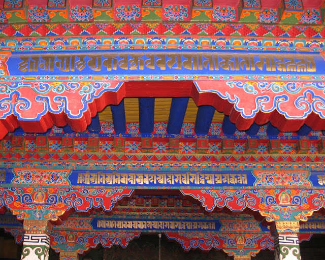
Stunning Color within the Potala Palace
Lhasa, Tibet - 2009
As with other temples that we have visited, the air inside the dimly-lit rooms is heavy with yak butter and incense, and the history of the various Lamas, and sect-founders is even more dense. The paintings are incredibly detailed, and I only wish I knew more about each image, each Buddha statue. These pilgrims walking beside me probably know each and every one and for them the place has the deeper dimension that comes with a lifetime of immersion in their faith, but for me they are incredibly beautiful, but mysterious. The wooden handrails that help keep us from falling to an early death are worn smooth by thousands – millions? – of hands.

Potala Palace Rooftop
Lhasa, Tibet - 2001
T H E   B L U E   B A G   S E C T
Photography is prohibited inside the rooms and temples here at the Potala, but they have several bookstands on the landings, selling books not available in stores, published by the Potala Palace with the funds going to help buy all that white-wash. Our group lines up at the last bookstand and does commerce, each book placed in a blue plastic bag. There were so many of us having them, that we christened ourselves as the Blue Bag Sect, a play on the various Buddhist sects (Red Hat, Yellow Hat, etc.), and declared our guide to be the founder. Those having the bags posed for photographs at the bottom, and we boarded our bus and trundled off to lunch.

Many times, an historical icon that one has yearned to visit can disappoint. But not the Potala. It is everything one can imagine and more. The views of Lhasa from the palace are stunning, and even though our lungs, at times, were complaining, I think that if members of the group could pick just one place to visit in Tibet, this would be it. Ask them.

Editor's note:  when I visited Lhasa in 2001, visitors to the Potala Palace were allowed to stay as long as they wished and also take photographs.  I have included some here.

Norbulinka Palace (Summer Palace)
Lhasa, Tibet - 2009
N O R B U L I N K A   or . . . The Lonely Planet Gets it Dead Wrong
I'm a great fan of Lonely Planet guidebooks and have lugged them around wherever we go – in China proper I tore the recent edition apart – as did many of our group members – rather than lug the whole thing. But I brought the entire Tibet Lonely Planet with me. The Lonely Planet writers can often be acerbic and dismissive, and they were about the Dalai Lama's Summer Palace, Norbulingka, saying that it ranks behind the other sights in Lhasa. They use the word "lifeless" in their description. Wrong. Dead Wrong. If you knew nothing else about the place, and glazed over when the litany of earlier Dalai Lamas who stayed there (#'s 7 – 14) were there I could understand it. But it is the 14th Dalai Lama's having stayed there, and then escaped from there that elevates the place to something special. Our guide pointed out on the large map at the entrance the route that the Dalai Lama took in 1959, dressed as a soldier to escape detection, as he fled the Norbulingka and set off on his exile that continues to this day.

Norbulinka Palace Gilded Roof
Lhasa, Tibet - 2009
T H E   F O U R T E E N T H   D A L A I   L A M A
The Dalai Lama's presence is everywhere here, in the commentary, in the furniture, the carpet. But his likeness is not. We have seen no images of the 14th Dalai Lama anywhere in China or Tibet. (And were warned not to bring any books or magazines with such images into China.) Since his receiving the Nobel Prize, and the March 2008 uprising, the Chinese government has seen to it that his image has disappeared. So much of Tibetan history and Buddhism is attached to images and likenesses. Statues and paintings of every major and minor figure are jammed into the temples. But there are none of the 14th Dalai Lama. It reminds me of the early Buddhist iconography where the artists and sculptors, unable to depict the Buddha who had transcended this word, left blank the space where he would be. Only the Buddha's footprint, or the animals worshipping him. You can almost see the indentation of the Dalai Lama where he had been sitting on the sofa. But the space where he would be is empty.

There is an audience room where the 14th Dalai Lama would receive visitors, dignitaries, pilgrims, and at the head of it is a low bench where he had held court and dispensed his incredible wisdom. On the surrounding walls is a history of Tibet that he had ordered be painted. It is a decidedly Tibet-oriented history and it is exquisite. It ends on the lower corner of the third wall (the fourth is windows), cut off by events in 1959 and following. When our guide got to the end of it and was standing near the bench, I asked him if conditions were ever such that the Dalai Lama would/could return to Lhasa, would he possibly be sitting there again? "Of course!" he said "This is his home."

I would suggest, respectfully, that Lonely Planet take another look. And this time open their hearts.

Outside the Norulingka Summer Palace
Lhasa, Tibet - 2009
A R T   &   L I F E  and Seven Years in Tibet
Almost from the beginning of his presentations both in Norbulingka and other important sites involving the Dalai Lama, our guide has been making references to the 1997 movie starring Brad Pitt: Seven Years in Tibet. He has never seen the film, but has learned bits and pieces about it from his tour groups over the years. He pointed to places at Norbulingka that were depicted (but not actually filmed) in the movie, and for him as with many other Tibetans he tries to piece together the bits and pieces he has heard. When I just tried to Google Seven Years in Tibet, it was not able to connect with any of the movie sites about it, and then my Google wouldn't work. The long hand of the Chinese government at work.

*******
Editor's note: text has been minimally edited to circumvent any possibility of censure by the Chinese government.

All of the images posted here are also available for purchase as 8x10 and 5x7 fine art prints and A2 size greeting cards (all printed on archival water color paper) at http://DigitalYak.etsy.com/. Be sure to send me a message if there is something you'd like that you don't see listed, or if you'd like a custom size or item, as I truly enjoy creating one of a kind items that hold special meaning. Thanks!!

Monday, October 31, 2011

Postcards from Lhasa - Part 1 - Guest Post from historian Sandy Lydon

We have a very special treat this week!  Sandy Lydon, emeritus professor (Asian and Asian American Historian), who has been leading trips into China and other parts of Asia for thirty years or more, is our Guest Writer on the ground, in Lhasa, Tibet. Sandy, along with Dr. Gary Griggs (geologist and oceanographer), and Dr. Cherie Barkey (Modern Chinese Historian) are leading an intrepid group of travelers, most of them from Santa Cruz, California, on an amazing 2 1/2 week adventure through China, Tibet, Hong Kong and Macao. You can find details about the trip itinerary on his website.

The Potola Palace from the Roof of the Jokang Temple
Lhasa, Tibet - 2009

The singular hallmark of Sandy's trips is the great preparation that travelers have in the 6 - 8 months prior to departure. They are immersed in learning of all the forces that have shaped the region - religion, language, history, conquest, trade, geography and politics - enabling them to have a nuanced and non-judgmental understanding of the people and places they are visiting.

This is the first in a three part series, which I know you will enjoy. Please feel free to respond with your comments. Included in this post are my own photographs taken on two previous trips to Tibet - in July of 2001 and then October of 2009.

L H A S A
Who hasn't wondered about, dreamt about, fantasized about and wanted to go to Lhasa? And the being here in no way resolves any of the dreams or fantasies. We say over and over again to ourselves and each other, "I'm in Lhasa." And smile. It is magical. Whether I'm able to make any clear, logical sense of it is another matter. Lhasa assaults the senses and being at 11,000 feet just adds to it. The air is clear and bracing, sharp on one's lungs that seem to be shallow. We don't breathe – we pant. We've been blessed with remarkable weather since our arrival – we left the clouds and chill of Xining for bright, deep, blue skies, much like one experiences at the top of ski lift. Allan McLean leaned over to me as we were walking through the park at the Norbulingka and said he had never seen a deeper blue sky, noting that the sky up the Santa Cruz County North Coast where he grew up (Rancho del Oso) is always hazy, even when cloudless. It is easy to see why both the Tibetans and the Mongols use a deep blue in their imagery, and symbols.

The Jokhang Temple on Barkhor Square
Lhasa, Tibet - 2001
Mid-day Prayers
Barkhor Square in front of the Jokhang Temple
Lhasa, Tibet - 2009
J O K H A N G   T E M P L E
After lunch (a sumptuous Americanized spread with meat, potatoes, pizza-like stuff, and a dynamite tomato soup), we journeyed over to the Jokhang, a temple complex originally built in the 7th century and then restored following fires and political destruction, most recently during the Cultural Revolution when the Red Guard desecrated the interior. Since then it has been restored and is so heavily used by pilgrims and so filled with yak butter candles and incense smoke that one would think it is over 1,000 years old. If Tiananmen Square is the political and cultural bulls-eye of the Chinese world, Lhasa and more specifically the Jokhang and the Potala Palace comprise the center of the Tibetan World. Throughout the afternoon we were surrounded by thousands of Tibetans, including little children and complete three-generation families, moving in the propitious clockwise direction, prayer wheels turning, humming their prayers and mantras. They have come from everywhere in the Tibetan World, wearing the clothing of their home areas, strolling and always with a look of surprise when they see us.

Prayer before Kora at the Jokhang Temple
Barkhor Square
Lhasa, Tibet - 2009
Kora (clockwise circumambulation of a holy site) on the Barkhor
Lhasa, Tibet - 2009
A movie was being filmed on the roof of the Jokhang (I cannot imagine the permits and bureaucracy THAT must required) and we watched as they filmed a scene of a young bewildered Chinese tourist trying to find himself. By that time, after a big lunch, the various Buddha statues and their attendants, the bodhisattvas, the Lama images began to blend together, and I was relieved when we finally entered the sea of humanity that was walking around the Jokhang.

On the Roof of the Jokang Temple
Lhasa, Tibet, 2009
T H E   B A R K H O R
It didn't take a genius to figure out that a river of circumambulating pilgrims provided a great opportunity to sell stuff, so as the hundreds of faithful walk around the Jokhang, they are flanked on either side by a continuous line of stalls, selling most everything, but heavy on the jewelry and Tibetan clothing and accessories. Most of our group members resisted the temptation, but there were some who shopped, such as Gary Griggs. I will not divulge what he bought for fear of ruining the surprise of his returning home with gifts. The square in front of the west entrance to Jokhang is filled with pilgrims prostrating themselves, and it is also this square that is the place where many protests and demonstrations began. It serves the same purpose for dissenters as does Tiananmen Square.

Shopping on the Barkhor after Kora
Lhasa, Tibet - 2009
Side Street Commerce on the Barkhor: Yak Jerky and Yak Cheese
Lhasa, Tibet - 2009
Side Street Commerce on the Barkhor: Lots of Veggies
Lhasa, Tibet - 2009
B U M P E R  S T I C K E R  P O L I T I C S
The two-word bumper sticker "Free Tibet" what one often sees on cars in Santa Cruz County makes it seem so simple. But, as Vicki Birdsall noted the other day, you can't winnow down the situation between China and Tibet into two words. It is a hugely complex issue, and as the locals will point out – it was the Chinese government's suppression of the March 1959 uprising that really marked the beginning of the end of any Tibetan autonomy. And, on the anniversary of that rising in March 2008, the Chinese government responded with a very heavy hand. Before and since, protestors (mostly monks) have chosen the Jokhang's Barkhor Square as their stage. And everywhere we look, there are uniformed Chinese soldiers. Not the type that you might see guarding an airport, though; these are tough even scary looking men. We have been told repeatedly not to take pictures of the soldiers. So, I'll have to try and describe them.

A N  O C C U P Y I N G  F O R C E
Some are stationed in guard posts, either located in the middle of the human river flowing around the Jokhang, or off on the side. At first blush these posts look like hot dog stands at the county fair, but the men inside them are not hot dog salesmen. They wear tan or sometimes camouflage uniforms, and shiny dark brown helmets. The posts have machine guns, and the soldiers holding them are wearing knee pads and shin guards much like a baseball catcher would wear. But the gear is designed to allow them to kneel and fire those fierce-looking weapons should the need arise. They look much like the storm troopers in Star Wars, and they walk with difficulty, a stiff gait, their legs reaching out far ahead of them. Each post has a large number of fire extinguishers set in the corners, and at first I thought it might be one of their other functions – to protect the wooden structures on either side of the human river. Then it dawned on me, and it was a chilling revelation. Those extinguishers were preparation should a protesting monk set himself on fire. They would want to douse the flames before any movie or still cameras could record the event and post it on the Internet for all to see.

Most military men standing on duty will crack a smile or grin in return of a grin from us. But there is no humor here in Lhasa, no laughter behind their eyes. They are tough, no-nonsense dudes. Most Tibetans do not make eye-contact with them, and the young ones that do have no laughter behind their eyes either. There is grim drama being played out here, one that does not seem to have an immediate resolution.

The place I am most familiar with where the cold eyes of an occupying force met a similar glance from the residents was in Ireland. Vince Versage, a member of our group, noted the same similarity. And, as do the present-day Irish, the Tibetans know the names of their martyrs and exactly where they fell. The British no longer occupy most of Ireland, but the Chinese occupy Tibet and have vowed to do so in perpetuity. Chinese patriots insist that Tibet is and always has been part of China, while Tibetans insist that claim to be tenuous. Our group members have read about the two views and we have discussed the situation, but seeing it first hand, and watching the squads of heavily-armed Chinese soldiers march through the crowds of pilgrims, I realize now that the problems are much more complex than I had even imagined.

From the beginning of this adventure back in January, I had asked group members to try and cultivate a position of neutrality before going to Tibet. Then, after the trip I plan to ask them what position they now hold on what is often called the Tibet Problem. You might ask them when they get home.

*******
Editor's note: text has been minimally edited to circumvent any possibility of censure by the Chinese government.

All of the images posted here are also available for purchase as 8x10 and 5x7 fine art prints and A2 size greeting cards (all printed on archival water color paper) at http://DigitalYak.etsy.com/. Be sure to send me a message if there is something you'd like that you don't see listed, or if you'd like a custom size or item, as I truly enjoy creating one of a kind items that hold special meaning. Thanks!!

Tuesday, September 27, 2011

Walking the Bay's Edge with Sandy Lydon and Gary Griggs

Who would have thought that it was actually possible to walk the length of Monterey Bay on the beach?

It's a novel idea and something that many adventurous walkers from this area have attempted on their own.  But it's also possible to combine a day (actually three days...) of fresh air and exercise with spectacular scenery, the camaraderie of a collegial group, and the expert knowledge of historian Sandy Lydon and coastal geologist/oceanographer Gary Griggs. It's called the "Bay Walk" and it has become an annual event that is truly an unforgettable experience.

Gary is fond of saying that he covers the first 200 million years of the region, while Sandy covers the last 200. Both Gary and Sandy are sought after for speaking engagements in their respective fields, as Gary has a gift for making science accessible (and inanimate rocks and drifting sand seem stimulating) while Sandy, well Sandy just makes history come alive. Together, they have a unique partnership, and it works really well.

Walking the Edge
Carmel Bay, California
The walk starts at New Brighton State Beach and ends at the Monterey Breakwater, just before Fisherman's Wharf. Over three days (three successive Saturdays) you walk an average of ten miles a day and and learn about tectonic plates, littoral drift, sea walls, Portola and the Missions of the the central coast, Japanese American abalone divers, and "By-the-Sea" developments of the 1920's.  You visit the World War II installations at old Camp McQuaide and discuss the significance of Mulligan's Hill at the Salinas River mouth.  Along the way you'll pass by the Dynergy Power Plant in Moss Landing that converts natural gas to electricity, the old Kaiser refractories where magnesium was extracted from seawater, and where Calera - "green cement for a blue planet" now runs a test facility that makes cement from sea water. Closer to Monterey, you pass by the Lapiz Sand plant - an operation that should have been shut down years ago, if only the public agencies that have jurisdiction over it could get through their own bureaucratic red tape. All in all, it's a three day experience that few of us could find on our own, even though it's right in our own backyard.

The photographs below were taken on Bay Walk 3 which took place in May 2011. While there are many opportunities to photograph signature views of the region - like the cement (concrete) ship and the sweeping panoramas of the Bay - I like to focus on the images most people overlook...close-ups of ordinary elements...unusual patterns...the juxtaposition of dissimilar objects and textures....the unexpected image that warms your heart and makes time stop.

Waves of Sand with Towers Looming Overhead
Give me Shelter
Follow the Leader
Boy and His Dog
Bounty of the Sea (with a light dusting of salt)
Rills
Skeletal Ice Plant
Message in the Sand
Sea on Sand
The air and exercise are what your body needs, the knowledge stimulates your brain, and sharing the rigors of the three day journey and its beautiful vistas with your fellow walkers is just great for your soul. You can find more information about the details of Bay Walk 3 on Sandy's website, along with many other walks that Sandy regularly schedules. Gary also wrote about the Bay Walk in two of his regular Sentinel columns last year: August 14, 2010 and August 28, 2010.

Other adventures that Sandy and Gary have undertaken together include: The Carmel Bay Hike, the North Coast Hike, the Hollister and San Andreas Hike, the 17-Mile-Drive Hike, and the Point Lobos Hike, just to name a few. I've been fortunate enough to be able to tag along on almost all of them and I could post a blog entry on each one, as they are all so memorable.  I always come away with a deeper understanding of the region and a renewed appreciation of the place I call home...and of course, hundreds of photographs.  You should try it sometime!

Several of these photographs are included in a desk calendar called The Bay's Edge, which you can find at my etsy shop: http://www.etsy.com/listing/82127349/2012-desk-calendar-the-bays-edge. All of the images posted here are also available for purchase as 8x10 and 5x7 fine art prints and A2 size greeting cards (all printed on archival water color paper) at http://DigitalYak.etsy.com/. Be sure to send me a message if there is something you'd like that you don't see listed, or if you'd like a custom size or item, as I truly enjoy creating one of a kind items that hold special meaning. Thanks!!